Recommendation points
A modern construction site can be compared to a large factory, all shops of which are aimed at producing responsible products. Teams and individuals perform different types of processes that are spaced out in time. Much depends on the well-coordinated work of related services, while quality control is becoming the cornerstone – after all, in the end, people will always be in the building. Complex electronic theodolites and devices for GPS observations are not available for everyone to work, but any builder who is interested in the quality of the work performed can master the level..
The site plan with elevation marks is the basis for construction. Relief data allows you to select the optimal location for the pit and calculate the point of discharge of surface waters.
So the task of leveling is to determine the height difference between points on the earth’s surface, called the elevation. Knowing the design elevation of the floor of the first floor of the structure, it is possible to calculate the place of discharge of storm water, or to provide for a tie-in point for a gravity drain.
In the arsenal of a specialist there are various tools and devices that allow obtaining local data without giving the general picture. For example, the moisture content of a certain material is determined with a hygrometer, but how do you know the degree of “swelling” of the entire structure? In this case, a level comes to our aid, with the help of which you can get the values of the object’s height and compare it with the control.
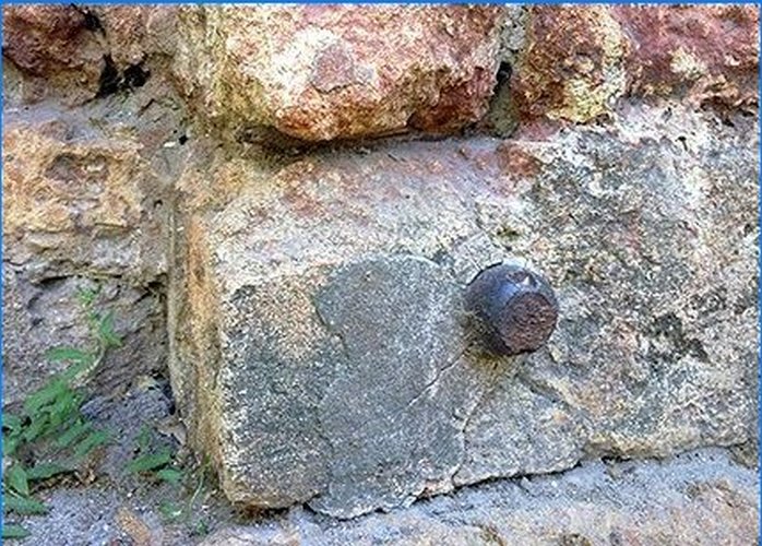
To do this, special marks are mounted in the front of the building along the perimeter, between which the excess is determined. If the marks are located at the same height within the tolerance – everything is in order, if one part of the building subsides faster than the other – it’s time to evacuate people.
Leveling methods
There are several types of determination of excess, however, in construction, the first three methods of the following are mainly used:
- geometric leveling – uses the principle of the horizontal line of the sighting beam of the instrument’s telescope, a level is used;
- trigonometric leveling – the principle of inclination of the sighting beam of the telescope of the instrument is taken as a basis, theodolite is used;
- hydrostatic leveling – based on leveling the liquid level in communicating vessels (water level);
- barometric leveling – depending on the height of the point, the indicator of atmospheric pressure changes (used in the mountains);
- automatic leveling – special sensors installed on cars transmit the inclined displacement vector to the reader (road works);
- stereophotogrammetric leveling – carried out on a complex hardware complex. Two space or aerial photographs, made with partial overlap, are loaded into a special device. When looking at them through the optical system, you get a “3-D immersive effect”.
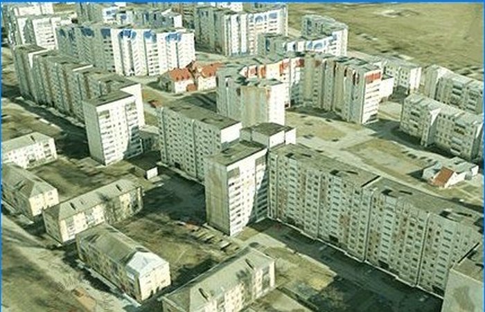
This is how, for example, a three-dimensional model of a neighborhood looks like, made using a stereophotogrammetric complex. Next, the binding of rigid terrain contours in the coordinate system is carried out, and we get a digital model for which at any point in the image you can get the height value by interpolation.
Tools and devices for geometric leveling
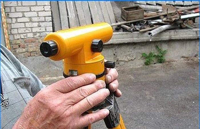
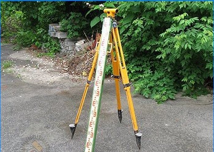
The main tool with which measurements are carried out is a level. The classic instrument is an optical-mechanical device, with the help of which the horizontal line of the sighting beam is ensured in space. The level is mounted on a tripod, installed on a standing point and brought to a horizontal position with special screws. The pipe of such devices can be both forward (modern models) and reverse images. Actually, there are no special problems when working with an inverted image – the measuring rod is simply installed upside down. To rotate the image, a special lens system is used, which affects the cost of the tool. Additional lenses also introduce minor distortions that are clearly visible under refractive conditions during hot seasons. For example, the visibility in a Soviet inverted theodolite is better than in an electronic total station with Carl Zeiss optics. Although this is not surprising – now there is no need for shooting at long distances, satellite geodesy methods are more suitable for this, and it is still more convenient to work with the “correct” picture.
Structurally, levels are of the following types:
- with a cylindrical level near the telescope
- with automatic compensator
- electronic
According to the accuracy class, tools are usually divided into the following groups:
- high-precision (N-05, N-1, N-2)
- accurate (N-3, N-3K, N-3KL)
- technical (H-10)
The letter “H” in the name of the instrument denotes the level, and the numbers – the root mean square error of measurements in millimeters per kilometer of distance. The rest of the letters indicate the design features of the instrument (limb and compensator).

Compensators are able to remove errors in the installation of the tool, which will increase the accuracy of the work performed. In the presence of a manual compensator, the tool is manually brought into the horizontal plane, but the self-leveling level is able to take the correct position automatically.
Leveling principle
The performer takes a reading on the staff (or staffs – front and back), which is installed on the point, and calculates the resulting excess value. The method when the instrument is installed between the measured points is called “Leveling from the middle”, and most often used in construction.
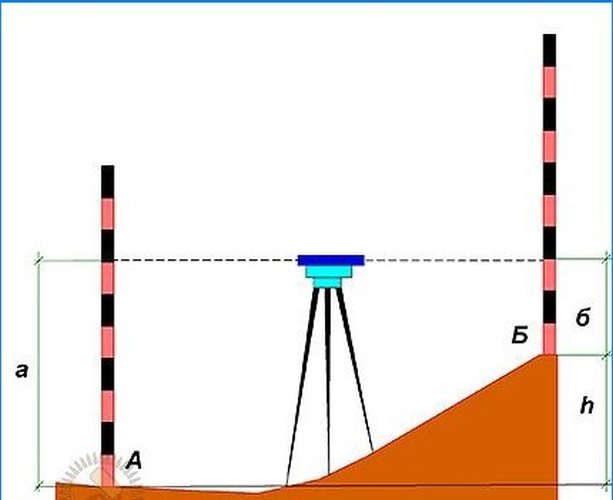 The principle of leveling by the “from the middle” method
As you can see from the illustration, the excess between points A and B will be equal to the difference in the readings on the staffs, and it can be either positive or negative. The excess itself will not help much for the production of work, there should be many such values, since their combination gives us an idea of the terrain. Therefore, as in the case of the theodolite traverse, measurements are taken from points with known heights, called “benchmarks”.
The leveling network originates from the zero of the Kronstadt foot gauge, which, as we remember from the previous articles of our cycle, is located on the shores of the Baltic Sea. Therefore, the system of heights used for the production of topographic plans was named “Baltic”. In our case, the absolute height of point B will be h = A + a – b, Where AND – point mark relative to the state system of heights, and and b – counting on racks.
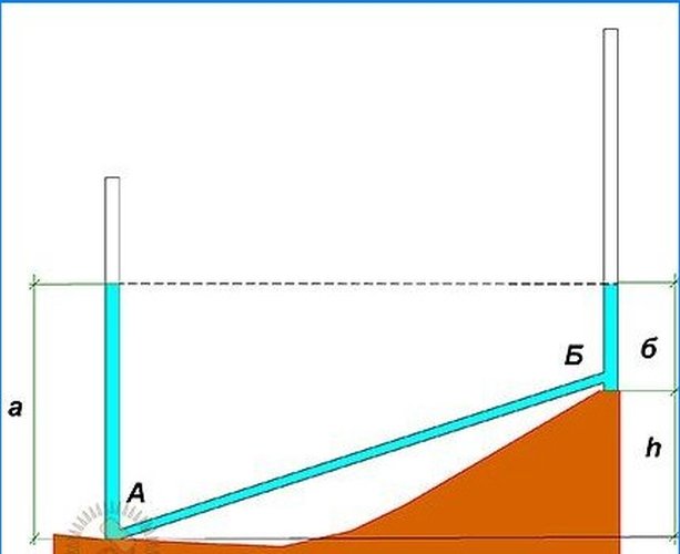
Another method of leveling involves using a tool instead of a staff. It got the name “Leveling forward”.
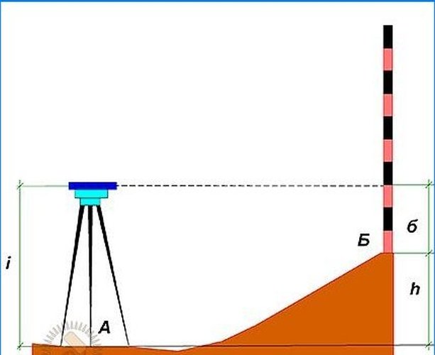 The principle of leveling by the “forward” method
In this case, the instrument is set to a point with a known height. The formula for calculating the height of point B takes the following form:
h = A + i – b, Where i – instrument height, measured with a tape measure.
This method is not always convenient in the production of work, because it is difficult to install the tool on the vertical surface of the wall, and it is much easier to work remotely without approaching the object..
Relatively speaking, the water edge of any body of water that has communication with the world’s oceans can be taken as the reference point. However, in this case, we can talk about a conditional system of heights, because the accuracy of determining the height in this case will not be sufficient for carrying out work, although this method can be used at local sites where there is no need to link heights with local systems.
Principle trigonometric levelingimplies the use of a theodolite or total station. In this case, the angle is measured from the horizontal plane to the top of the staff or inaccessible object. It was by the trigonometry method that we determined the height of the power line support in the previous article of our cycle. This method is less accurate than geometric leveling, however, it allows measurements over long distances and at significant angles of inclination of the terrain..
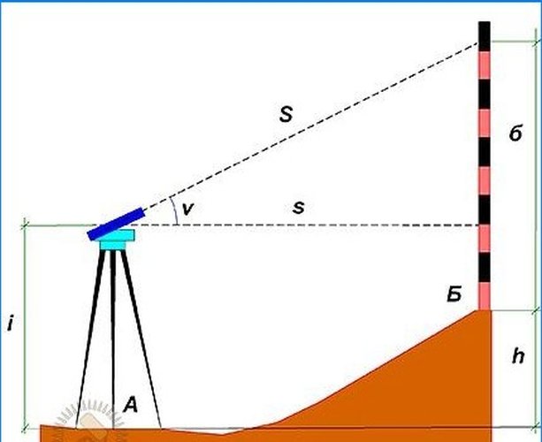 The principle of trigonometric leveling
In this case, the working formula for determining the height will take the following form:
h = s * tg? + i – b or h = S * sin? + i – b, Where ? – the angle of inclination of the beam, s – horizontal distance of the line, S – hairline length, i Is the tool height, and b – sighting height.

Hydrostatic levelsunpretentious, easy to use and provide quick determination of excess. This type of leveling is well suited for automating measurements..
Scope of application of hydrostatic levels:
- installation of large equipment;
- leveling of foundations;
- finishing and architectural work;
- laying plumbing equipment and pipelines;
- determination of the horizontal guides;
- monitoring deformations and subsidence of buildings and structures;
- transfer of height through water obstacles, etc..
The principle of operation of such a device is shown in the figure.
 Principle of hydrostatic leveling
As you know, in communicating vessels, the level of the liquid is leveled. The desired excess h can be found by the difference between the readings a and b, which are taken on a special scale built into the vessels. This method allows you to work in confined spaces, does not require special skills, but does not always provide the required accuracy (measurement error in this case is ± 10 mm) and creates inconvenience when moving the connecting hoses.
Laser levels
The electronic type of levels allows you to visualize several planes at once by projecting a laser beam onto objects and structures. For example, the rotary vane rotates at 400–550 rpm or more. With this device, you can make markings both indoors and outdoors, in daylight or at dusk. These levels are indispensable for wallpapering, tiling or installing structures with minimal tolerances. The laser level allows you to measure point elevations, level or mark slopes. When using a laser tool, you will forever forget about rope plumb lines and metal squares, which are especially inconvenient at distances of tens or even hundreds of meters. Marking is now possible at any angle, even in the most inaccessible places.
Laser instruments are safe as they belong to the second class of instruments in terms of radiation power. The beam from the laser level can harm only in the case of prolonged projection onto the human eye. Most of the tools produced for construction are protected from shock and moisture ingress, as this can affect the performance of the tool. Under unfavorable conditions, it is worth buying special glasses that improve the visibility of the beam..
As with any other construction tool, preference should be given to models of well-known brands. Levels and laser levels must be verified annually. If you work with an imprecise tool, and drive the centimeter residual into the elevation of the first floor, you may not have a floor slab on the top floor. So study the articles of our series, use modern equipment and polish your skills. The constructed structure is the result of the painstaking work of many specialists, who would really not like their work to be demolished due to the carelessness of surveyors.
When it comes to construction work, leveling is essential for ensuring accuracy and precision. But what techniques or tools do geodesists typically use for leveling purposes? Are there any advanced technologies that have been introduced in recent years to enhance the leveling process?
Geodesists typically use various tools and techniques for leveling purposes, including traditional leveling instruments such as automatic levels, digital levels, and total stations. These tools help geodesists measure height differences and ensure accurate leveling during construction projects.
In recent years, advanced technologies such as laser levels and GPS systems have been introduced to enhance the leveling process. Laser levels use laser beams to establish a reference line or plane, making it easier to ensure precise leveling. GPS systems, on the other hand, use satellite signals to determine accurate elevation data, facilitating quicker and more efficient leveling measurements.
Overall, these advanced technologies have revolutionized the leveling process in construction work, allowing geodesists to work more efficiently and accurately than ever before. By combining traditional leveling tools with modern advancements, geodesists can ensure precise and reliable leveling for construction projects of any size or complexity.
What specific techniques or methods are commonly used in leveling for construction work?
How does leveling contribute to the foundation of construction work and why is it considered a crucial aspect in applied geodesy?
Can you explain the importance and process of leveling in construction work?
Leveling is crucial in construction work as it ensures the stability and accuracy of structures. The process involves determining the elevations and slopes of various points on the construction site. Firstly, a benchmark is established as a reference point. Then, a leveling instrument, such as a level or laser level, is used to measure the difference in height between the benchmark and other points. This data helps to create a level foundation, ensuring that structures are aligned correctly and prevents potential issues such as water drainage problems or unstable structures. Accurate leveling is essential for safety, functionality, and long-term durability in construction projects.
Can you provide more information on the specific techniques and methods used in leveling for construction work in the field of Applied Geodesy? What are the key considerations and challenges in ensuring accurate and precise leveling measurements?